A Short Kayak Trip 3/20

Last Monday, I woke up at 5 am. Had a cup of tea and a Lara bar, loaded up my kayak and fishing gear and headed to Saint Augustine for a quick fishing expedition.
I stopped by Avid Angler for some mud minnows and got to the boat ramp just before 8 am.
I had been in desperate need of some “reel therapy” since I hadn’t been on the water in a month in a half, and today looked promising since I was going to be able to fish the last hour and half of the out going tide.
So I drop the kayak on to the ramp, park the truck and carry my two rods, tackle box, life jacket, bait bucket, and fish bag down to the kayak and get set up to take off.

Just before I got into the kayak, an elderly gentleman pulls up to the ramp with his boat and offers to give me a push off the ramp. Knowing I could handle it and not wanting to trouble him, I thank him and tell him “I’ve got it” and scootch my way back and forth until I slide off the ramp into water, giving the man quite the chuckle. I smile and tell him it’s my workout for the day.  We say good luck and I’m off to find my spot to hopefully catch some fish.

It was sunny, and temps were in the 50’s, so I bundled up.  Low tide was at 9:30. I paddled out to a spot that had produced small trout for me before and was hoping those trout may have grown some since last time. Oysters line the banks on both sides of the water on a creek that dumps out into the Intracoastal and I can see a few splashes here and there, like something making a meal of those oysters.

I put a mud minnow on a jig head, cast, then BAM!
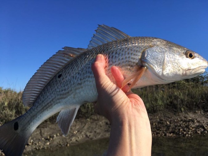
IMG_0320

16 inch redfish.

Alright! And we’re off to a good start! Not a keeper, but it’s catching!

So I get a picture, send the little guy on his way, fish out another mud minnow from the bucket, put him on a jig head and cast again.

And BAM!

IMG_4453

A 17 inch red this time.

We’re getting warmer!

Cast again, and BAM!

IMG_4454

And there it was…

A personal best that had me jumping for joy, well not jumping, but hallering like a lunatic and had anyone heard, they would have thought me mad!

A 20 inch speckled sea trout!

And yessir, that’s dinner!

I could have gone home happy at that point, but hey! The fish were biting!

I kept catching under size reds for a day’s total of 5 and even a little Jack Crevalle. One red was 17 1/2 inches, just under size, but they all were great fighters, and it made for a great day of fishing.

IMG_0323

This was the last one.

Around 10, the bite stopped and the wind started to pick up. And that was my cue to paddle back to the ramp and call it a day.

It was refreshing to have such a great day fishing after not fishing for such a long time.

And it was tasty to fry that trout up for dinner!

Texas Hill Country: Part Three

“I do not intend to tip-toe through life to arrive safely at death”

IMG_0311

Wednesday was our last day in the Hill Country.

We couldn’t ride the whole day since we were meeting a friend that evening, so we had to make the most of it.

We left Junction for the last time with sunny, clear skies. After a quick Micky-D’s breakfast were off on 2169 again.

We decided to do the ride to Enchanted Rock then head to Cooper’s in Llano for lunch before moving on to Horseshoe Bay where we were staying for the night.

From 2169 we took RR 479 east to CR 470 north then north again on CR 412.

Some of these roads we had taken the day before, but going in the other direction. And with the  change in cloud cover it made for a different view of the scenery.

IMG_0248IMG_0252

Then we took CR 410 north and east to CR 420 or  Blue Mountain Road.

IMG_0258

And yes, the cow is on THIS side of the fence. Her and all of her cow friends.

Then it was back on pavement to RR 385 southeast.

IMG_0261

And then it was our first time getting lost for the day.

We were suppose to be looking for Mill Creek Rd north. Well there’s no sign for Mill Creek Road.

We rode all the way until 385 dead ends into Hwy 290 then turned around and headed back.

After blowing up the map on the trusty (Ha!) GPS we found the road we needed to take after Mill Creek Rd and that lead us to find our way in the right direction. It turns out it was actually CR 430 according to the GPS.

From CR 430 or Mill Creek Rd, we took East Mill Rd and that brought us to our first water crossing of the day, Little Devils River.

IMG_0269

This one didn’t even look like a road, more like the river had removed it.

IMG_4290

So East Mill Rd turns into Salt Branch Road, according to the book. It’s actually Salt Branch Loop so says the mighty GPS and I don’t know if it’s the GPS’s fault or Earl reading the wrong page in the book, but we ended up taking the road that leads to the largest, most difficult water crossing for dual sport riders in all of Texas.

Well, maybe not all of Texas, but the Hill Country for sure.

But before I get to that…

We were riding along on East Mill Road.

IMG_0276

We came to a road that we made a left on when we should have just kept going.

So we’re riding along this road, enjoying the countryside.

IMG_0281IMG_0283

And then we come to our second water crossing of the day.

IMG_0294

This one was rock, not dirt and it was slippery. Very slippery, but we made it across.

Just past this water crossing I saw a sign that said Eckert James River Bat Cave Preserve and while I was pondering what a bat cave preserve was, an alarm went off in my brain.

James River.

James River Crossing.

Oh shit.

And around the bend, my suspicion was confirmed.

My first thought was Earl came this way intentionally to scare the crap out of me.

Allow me to mention a billy-goat road in North Carolina where you can hear my not-too-happy voice sprouting profanity on the GoPro video that still makes Earl chuckle to this day.

But that’s not what happened. Innocent mistake, but now what to do?

Crossing was way too risky since we were out there alone, and everything we had with us was loaded onto the bike since we were between motels so the smart thing to do was turn around.

And that’s exactly what we did.

I could have sworn we took a picture of the James River Crossing, but I’ll be damned if I can find it.

So here’s a picture of Earl crossing this one again.

IMG_0295

And if it looks slippery driving across, try walking across it. I came very close to busting my ass making my way to the other side to video Earl crossing.

So we got back to the road we were suppose to be on and made our way to Onion Creek Rd.

From there we went south on Hwy 783 to Threadgill Creek Rd.

Now I would be leaving out a major detail of the Hill Country in April if I didn’t mention the Blue Bonnets.

IMG_0304

And more Blue Bonnets…

IMG_0326

Lots and lots of Blue Bonnets…

IMG_0330

And this photogenic gal…

IMG_0320

Awaiting her close-up amongst the Blue Bonnets…

IMG_0318

From there, it was time to make our way towards Llano and lunch. We hopped on Hwy 2323 north.

IMG_0340

I could see Enchanted Rock in the distance on our way to Llano. We didn’t get to stop to hike it this trip, but that’s just one more excuse to take a bike trip out that way again, not to mention the BBQ.

IMG_3374